In 2011, I was asked to do a profile for a website called “What People Do”, but sadly, it’s no longer active. I found it really interesting as you could filter by different school subjects, or professions you’d heard of. Then you could read about all sorts of adjacent job titles and descriptions of what they did.
I’ve just found the entry I submitted on my emails, and I thought it was worth sharing for those interested in the “life of a cartographer”.
* As I originally wrote this role description in 2011, I have added some notes in italics to update it or add context.
Brief CV:
Degree: BSc Cartography, Oxford Brookes University.
Pindar Graphics: 2001 – 2008
Steer: 2008 – 2024
(Event Maps Global Ltd: 2024 – present)
Graduate job:
After university, I was employed by Pindar Graphics (now Pindar Creative) in Buckinghamshire, where I worked for 7 years. I started out as a cartographer in a team of 4 people, developing my skills in web mapping and working on interactive online transport maps. I worked closely with the web team, advising them on the cartographic side of things, which is where I learnt HTML and other really useful web development skills. My A-levels were in geography, media studies and maths, but I’m naturally more artistic. Cartography is a perfect fit of the two sides of my personality.
Second job:
In early 2008, I moved to Steer Davies Gleave (SDG), and I worked in the Integrated Design team. I worked alongside web designers, the CAD team, and graphic designers on projects varying from technical transport planning to more ephemeral outputs like wayfinding and signage. SDG are an independent global transport consultancy. A lot of people at SDG have been here for a long time. There’s a low turnover of staff – there are some directors here who set the business up 32 years ago. (note: remember this was written in approx 2011)
Projects:
Steer’s work ranges from large infrastructure projects to smaller soft-measure implementations. I’m currently working on a large project for Swindon Travel Choices, getting people to travel more sustainably. We do transport advice work for lots of major events, for clients like Wembley Stadium, Olympic Authorities and UEFA. We have created modelling of pedestrian flows in various stadiums, planning how people will get all the way from their seats to the nearest transport hub.
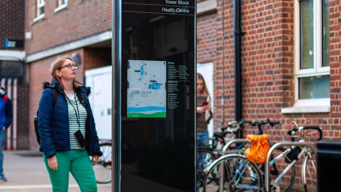
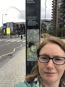
I have worked on the map signs for various wayfinding projects – the signs you see in the pavement indicating local landmarks on maps and directions to various places.
As a consultancy, it’s not just about the final map. It’s about planning and understanding how people move about places. We recently made guidelines for implementing the signs for National Rail. As well as designing the look of the signs we wrote the guidelines on the best places to position signs. It covered how to direct people, considering how people relate to things within spaces. For example, after going up an escalator, we calculate where they are most likely to turn, and advise how to place signs to influence the flow of pedestrians depending on the signs they encounter. It’s very rewarding to implement a scheme and witness it working and improving public spaces without the public even realising!
My working life:
On my team I’m the only cartographer. There are two 3D specialists, 3 graphic designers, 1 web designer and 2 urban landscape designers, plus the director of the team. My time is split between support for my transport colleagues projects and my own clients projects.
In my support role I produce maps as well as graphic outputs (schematics, cover designs, artwork etc). I’ve got a lot of the same skills as graphic designers, and in fact I’ve trained some of the new graphic designers in cartography to develop their skills too. This work can be very demand responsive. You have to be willing to broaden your skills and put the hours in when the deadline requires it.
When I work on my own clients projects, I am able to manage the timelines much better and can coordinate the team around their best skills. The Geographic Information System (GIS) team assist me on the analytical side of mapping – finding out which types of people live where, to assist in targeting our projects. We then take that data and design the maps to get the message across to the user, in the most appropriate way.
There’s quite a few opportunities for travel with work. The major transport authority for Rome – ATAC – are one of my clients. We created an automated mapping system for them, and then went over to train them to use the system. I also travel round the UK to see clients, and there are lots of opportunities in the company to go to our other offices for six months or so. We have offices in Sao Paulo and Canada – both large areas in terms of development work.
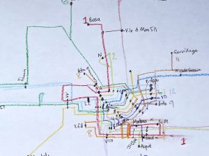
Making a map:
You have to start with finding data through a GIS system, Ordnance Survey data or open source data like OpenStreetMap. OSM is a huge movement which involves people mapping the area around them for themselves, like the “Wikipedia of maps” where all can contribute. We then collate the data and bring it to the design studio.
We use Adobe Creative Suite mainly, backed up with ArcGIS. From there, we apply a map style. Sometimes we have to match a brand, by using a particular font (for example for Transport for London we use New Johnson, which was created for TfL in the 1930s, and is very recognisable).
If there are no design guidelines, we usually test a few options out and ask the client to give us their opinion. Once we get their approval, we can finalise the full map. We then output to any format the user requires – JPEG or PNG for online, or PDF for sending to the printers. Less projects are printed now than they used to be, with the huge popularity of handheld devices, but the process to create the map is the same.
The industry:
80% of the people I went on to work with originally were ex-Oxford Brookes students like me – the industry is quite small like that. Upon graduation, there were a handful of key employers all the students went to each year. It’s a small world and you do tend to bump into the same people all the time.
Working for a well-established cartographic house like Ordnance Survey you have very little influence over the styling, so your design role is less, but it’s a huge icon throughout the world, and very well respected in the industry. The same is true of The AA and Collins Bartholomew’s, other big employers.
In smaller companies you have more control over the design output, and can build the house style. That can be very rewarding.
After university, lots of my fellow cartography graduates went to work for The AA or into the GIS side – working for industry suppliers of GIS (e.g. MapInfo and ESRI) so they work more on the geographic systems rather than producing maps. There are lots of maps that go into publications like travel guides, many of which are outsourced to freelancers. Lots of people go into freelance work once they’ve found their feet in the business. It’s more difficult and riskier generally day to day of course, but if you manage to get some good clients then you’ll get repeat work every year.
One question that a lot of people ask is “Hasn’t everywhere already been mapped?”. But there’s never a map showing exactly what people want – even if something’s already been mapped it can always be mapped again, and portrayed in a different style, showing different thematic information. When I was looking at cartography jobs before Steer, I interviewed at Dorling Kindersley, who produce a huge range of guide books. Also, during University holidays I used to work for English Nature (now Natural England), mapping Sites of Special Scientific Interest.
British Cartographic Society:
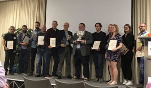
I’ve been involved with the British Cartographic Society (BCS) since university, in quite a few voluntary roles. I used to help coordinate the Awards each year, and now due to my web skills, I run the BCS website and social network feeds. I also volunteer by going into schools to teach about mapping the Japanese Tsunami in 2011 to Year 10s. We study maps for the morning, and by the end of the session they have to produce a map to say where they would have put the emergency services, and work together in teams to agree a strategy and use the map information to help them analyse the situation. It teaches them how to use a map for emergency planning and fits into their Restless Earth syllabus. Going into a school and teaching was new to me, and I get a lot of personal reward from it.
People aren’t introduced enough to cartography as a career option.
I would definitely recommend anyone interested in cartography to join the British Cartographic Society. It’s a small industry so being a member of the society can get you familiar with everyone else. There are so many technological changes in the industry – with OpenStreetMap, and developments from Google Maps – it’s good to be kept up to date. (Glad to see I was recommending joining the BCS all those years ago still!)
Different sides to the job:
Favourite aspect of my job: Designing a map from scratch. I sit down, get the data, and try to design an appealing style. I then get input from my colleagues, and between us we develop something that is aesthetically pleasing and gets the message across clearly. It’s a good feeling to spend time doing that, particularly when at the end of it the client is happy and comes back for more.
Least favourite: It’s getting better as I’m having more practice, but it’s probably the admin side of a project with budgeting and finance challenges. Managing other people is also a big challenge. It’s so unknown. However hard you work, and whatever plans you make, if you don’t get the team working together, it’s hard to get to the same end point. You have to know who’s doing what, and be in control.
Advice:
My advice would be to try and have a broad range of different maps in your repertoire. I’ve gone into transport maps but there’s topographical, geological, interactive, tourist, hydrographic charts – try a broad range to see what you really like.
I would also advise getting to know people in the industry. It really helps. We post jobs and student placements on the British Cartography Society website – look out for things online. Attend events – there are lots of free ones in London and many events issue student grants to attend.
Room for improvement?
I would change the working hours. Officially, it’s 9am-5.30pm, but that’s a rarity. For the design team we often start a little later, as we’re in Central London, but carry on working much later. In reality, I work well over 40 hours a week. The work is reactive and with different offices around the world we have to respond to them. If we’re working with the office in Vancouver, we’re leaving for home when they’re waking up. This can work very well at times as we can pass things over for when they start, but we still need to be able to speak to them sometimes to iron out any problems and this can sometimes mean working much later.
Leave a Reply
You must be logged in to post a comment.