Overview
I am honoured to have been recognised in several award schemes over the years for my cartographic and design skills, as well as my contribution to the UK geospatial industry.

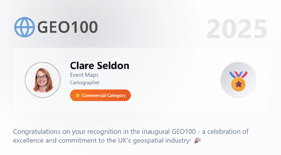
GEO100 list winner
Recognizing My Impact and Contributions to the British Cartographic Society.
Visit the GEO100 website for the full list www.geo100.com
#GEO100 winner 2025
The judges announced their selected inaugral GEO100 for 2025 on GIS day November 19th 2025.
There’s no ranking – the GEO100 is simply a celebration of excellence and commitment to the UK geospatial industry. Everyone from industry veterans to academics, freelancers and early-career professionals, to commercial leaders and beyond.
The judges believed these 100 individuals collectively represent the breadth of talent and diversity in our vibrant sector.
My Entry into the GEO100 list:
Recognizing My Impact and Contributions to the British Cartographic Society.
Background and Credentials:
I am an experienced cartographic designer and lecturer with over 25 years of expertise in wayfinding, transport, and event mapping. I hold a BSc in Cartography from Oxford Brookes University and have been a Chartered Geographer with the Royal Geographical Society since 2014. Throughout my career, I have received numerous accolades, including recognition in the BCS Awards, the Wallis Award in 2014, and a feature in Atlas of Design Volume 7 (2024). Most recently, I founded Event Maps Global Ltd, a cartographic design business serving architectural firms, transport consultancies, wayfinding designers, and select charities that are close to my heart.
My Role at the British Cartographic Society (BCS):
As a dedicated member and contributor since my final year at university in 2001, I was subsequently elected as a Trustee and Council member in 2021. In this voluntary capacity, I lead the social media outreach and the ongoing development of cartographic education through the Society’s GeoViz initiative.
Over the years, I have served on numerous committees as a volunteer, including organizing the Annual Awards (2004–2007), acting as webmaster (2008–2014), and pioneering our presence on platforms such as Facebook and Twitter. I have contributed to the Maplines Magazine and led the Better Mapping 2 seminars on digital cartography from 2010 to 2017, while supporting the original seminar series that started in 2006.
Advancing Online Engagement:
In 2017, I launched our Instagram account to enhance our presence with visual examples via #MapMondays, which resonated strongly with our professional membership seeking good examples of cartography. In 2020, the Society swiftly recognised the importance of online engagement and social media for maintaining membership and outreach. I organised the development of regular, engaging content beyond the traditional event announcements, fostering a vibrant online community. Recognizing the growing importance of diverse platforms, we expanded to include LinkedIn, YouTube, Bluesky, and more recently TikTok, collectively amassing over 12,500 followers across seven social channels, and supporting membership growth.
Paul Naylor, BCS President said “Clare’s dedication to the British Cartographic Society shines through every tweet, post, and story she shares. Her work on social media has not only elevated the visibility of BCS but has also created a vibrant, welcoming space for cartographers, map enthusiasts, and the wider geospatial community. Clare has a remarkable ability to distill complex ideas into engaging content, whether she’s promoting events like Tea Time Talks, celebrating member achievements, or spotlighting innovative mapping projects. Her tone is always inclusive and encouraging, helping to foster a sense of belonging and pride among members. Through her creativity and consistency, Clare has grown our online presence, expanded our reach, and helped attract new audiences to the Society. She’s also instrumental in amplifying the voices of others, highlighting diverse perspectives and ensuring that BCS remains a dynamic and forward-thinking organisation. Clare’s work is more than just communication; it’s community-building. Her passion for cartography and her commitment to the Society’s mission are evident in everything she does. We’re incredibly fortunate to have her steering our digital storytelling and helping shape the future of BCS.”
Adding Value:
- Our enhanced social media presence has not only benefited the BCS but has also become a beacon for other geospatial organisations, like the Swiss, German and Austrian Cartographic Societies. Some of which have reached out for guidance based on our strategies. We have shared insights to support their development efforts, fostering a supportive network within the european cartographic community.
- Supporting GeoViz and sharing the toolkit is very important to me. I actively collect member feedback at trade shows such as GEOBusiness and EsriUK, and organized a 1.5-hour workshop at our annual conference in Nottingham, showcasing the GeoViz Toolkit’s capabilities to enhance professional skills.
- In collaboration with Liz Fox-Tucker at the RGS, I provided evidence to support the Society’s CPD certification, ensuring BCS events, toolkits, and conferences continue to facilitate professional growth. I am also participating at the RGS’s Professional Insights series in September and May 2026 to support Chartered Geographer.
Recognition and Future Aspirations:
As part of our wider marketing efforts, I nominated the BCS for “Best Social Media” at the biz4biz Awards 2025, sponsored by Barclays. Following a top-five placement in the public vote and an interview with the judging panel, we were shortlisted, which helped raise our profile.
My next priority is integrating the GeoViz Toolkit into our membership benefits, providing practical workshops and demonstrations to show its application, alongside various software. With additional funding, and working with the GeoViz lead, we aim to develop online tutorials via our YouTube Channel and extend our toolkit to include chapters on AI and 3D mapping.

Selection for the 2024 Atlas of Design – Volume 7
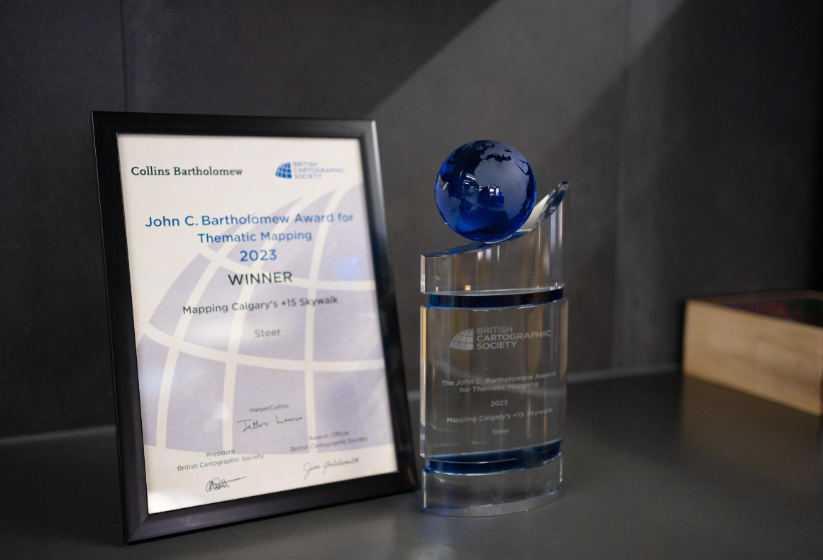
British Cartographic Society and John C. Bartholomew Award for Thematic Mapping 2023
Calgary +15 Skywalk
Snaking through skyscrapers across the city’s downtown, the +15 Skywalk is a 16km indoor pedestrian network of elevated walkways and 86 bridges connecting over 100 buildings. However, it can be a challenge to navigate for those who live, work, and visit downtown.
Therefore, The City of Calgary commissioned Steer to develop a clear wayfinding system that improves accessibility and makes it easier to use the +15 Skywalk network, attracting more people and creating a better overall experience.
Award winning
In September 2023 the British Cartographic Society and Collins Bartholomew presented Steer with the John C. Bartholomew Award for Thematic Mapping. The award is presented for originality and excellence in the field of thematic cartography, with emphasis on effective communication of the intended theme. Subsequently, in Spring 2024 the map was selected to be in the next edition of the Atlas of Design by the North American Cartographic Information Society, where it appears with a brief commentary on the work behind the map.
“I am truly honored that our diagram of this complex pedestrian network has been selected and will appear alongside some of the world’s best examples of cartographic design. Being involved in the early development stages in understanding the geography and connections of the area, lead to this meticulously designed and beautiful map.
Above all, I am overjoyed to have played my part in such a successful city wayfinding project that is improving access across Calgary with the installation of further signage.” Clare Seldon, Event Maps.
Order your copy of the North American Cartographic Information Society (NACIS) Atlas of Design: Volume 7

Commended in the 2024 Avenza Award for electronic mapping – Transport for the South East Story Map
TfSE launched an interactive Story Map which enables users to easily search for schemes within their areas and to discover how they will improve their everyday journeys.
“I was greatly honoured to receive a commended certificate in the BCS Avenza Systems Inc. Award for my TfSE StoryMap. Thank you to the sponsors, judges and British Cartographic Society for such a great conference and high quality awards scheme that showcases such a variety of cartography across the UK and wider community” Clare Seldon, Event Maps.
Check out the map on the Transport for the South East website
https://storymaps.arcgis.com/stories/e1edbac864a24dbf933a353193c601a8

TfSE’s Head of Analysis and Appraisal, Sarah Valentine, said: “Delivering our Strategic Investment Plan requires a number of partners, including TfSE, local transport authorities, National Highways, Network Rail and DfT, to work closely together to develop and deliver the schemes and policy interventions it sets out. Being able to track delivery progress of each of the schemes, to understand the inter-relationships between them and effectively communicate the plans to partners and wider stakeholders is crucial to the successful delivery of the plan.
Whilst we already had a suite of technical documents at our disposal, Story Map has really changed how we can do this, providing a visual, interactive and engaging site that really brings our SIP to life.”
Transport for the South East’s Chair, Councillor Keith Glazier added: “Over the last three years, a vast amount of time went into working with our partners and stakeholders across the region to figure out where investment was needed to deliver our Transport Strategy vision. As we put our Strategic Investment Plan into action, the Story Map helps show exactly which interventions are delivered in each area. The map is a useful tool for anyone that needs to find that information quickly.”
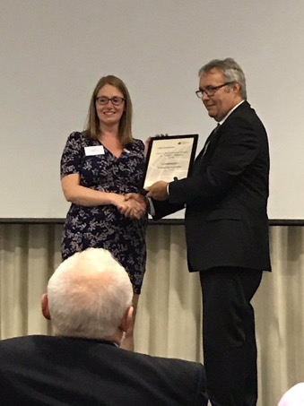
2014 Wallis Award for excellence in cartography


Tour de Yorkshire Splashmap
Design
The Tour du Nord maps are broken into the two stages of the “Grand Depart” held in Yorkshire in 2014. Each stage covered two maps at 1:40 000 and each map was divided into two more-or-less linear sections. In other words, we could design the whole of each stage as two beautiful scarf sized Splashmaps, despite the length of the Routes measuring 190 and 201km!
As a result, the practicality of the maps was picked up in the Yorkshire Post as it gained momentum for the Get Yorkshire Cycling campaign.
Award winning
Consequently, the success of the maps was rewarded by receiving The Wallis Award, presented to us by The Society of Cartographers.
Specifically the judges loved the maps, with comments highlighting the “Very user-focussed design”, “Effective use of a novel medium, retaining graphic clarity” and “Good visual hierarchy, and sensible selection of features”.
Other recognition:
- Highly Commended in 2019 John C Bartholomew Award for thematic mapping – Mexico City Nochebus Local Area maps
- SEGD Merit Award – Brick Lane threads wayfinding & connectivity strategy
- Commended in 2016 Stanfords Award for printed mapping – TO360 Toronto Wayfinding Map
- 2013 Avenza Award for electronic mapping – Swindon Travel Choices
- Commended in 2012 Stanfords Award for printed mapping – Edinburgh Travel Map (Easter Bush Campus)
Wayfinding ↫ Major Events ↟ Transport ⇌ Lecturing ⍟ Award winning maps